Quick Facts
Where is it? North Atlantic Ocean.
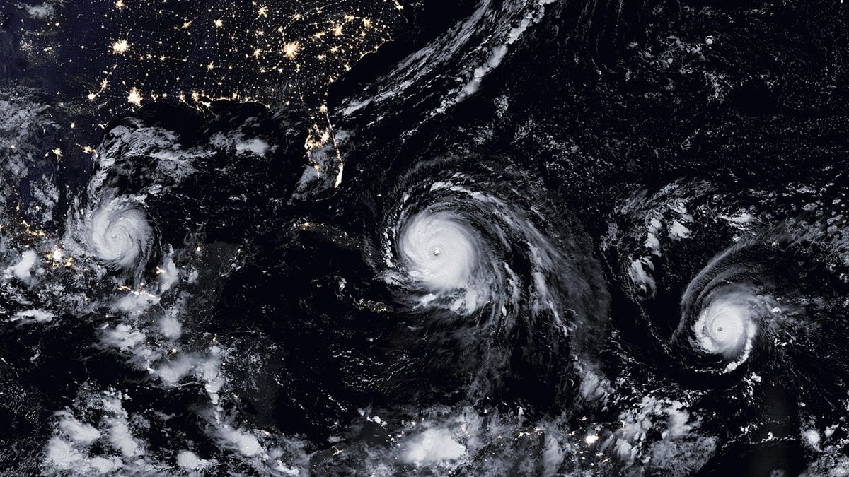
What is in the picture? Hurricanes Katia, Irma and Jose in a near perfect line.
Which satellite took the photo? Suomi National Polar-orbiting Partnership (Suomi NPP).
When was this photo taken? September 8, 2017.
In this 2017 satellite image, three hurricanes — including one of the most powerful tropical storms of the past decade — form a near-perfect line as they marched through “hurricane alley.” Some of the swirling storms, which initially appeared to be in the wrong order, later made landfall in the U.S. and Mexico.
The three hurricanes — Katia (left), Irma (center) and Jose (right) — were spotted by the Suomi NPP weather satellite, which is jointly operated by NASA and the National Oceanic and Atmospheric Administration (NOAA). Although they appeared to be tracking each other, the storms were moving in different directions: Katia made landfall in Mexico on September 9; Irma hit Florida on September 10; and Jose finally dissipated off the coast of New England on September 22.
Most Atlantic hurricanes form in the same stretch of water between northwest Africa and the Gulf of Mexico, known as the hurricane lane. But it’s rare to see so many of them so close together — and forming such a regimented line, according to NASA’s Earth Observatory.
Major Atlantic storms are named alphabetically based on the order in which they occur in each year hurricane seasonSo it seems strange that Katia is in line to come ashore before Irma and Jose.
The storms didn’t form in the order they appear in the image, however. Irma formed first, on August 30 near the Cape Verde Islands in Africa. Jose then appeared on September 5 in the mid-Atlantic, not far from where it is in the image. Katia also formed on September 5, slightly after Jose, but was born in the Bay of Campeche in Mexico, making it the closest to land in the image.
Related: 12 Amazing Images of Earth from Space

Hurricane Irma was the most destructive of the three storms. The powerful Category 5 storm produced storm surges up to 8 feet (2.5 meters) high, dropped up to 20 inches (50 centimeters) of rain in some areas and spawned at least five separate tornadoes, the National Weather CenterOne person was killed directly by the winds, which reached a maximum speed of 210 km/h, while 33 people were killed indirectly by the storm.
At the time, Hurricane Irma was reported to have the greatest accumulated cyclone energy (ACE) — the total amount of wind energy generated over the lifetime of a tropical cyclone — of any tropical storm on the planet, according to NASA’s Earth Observatory. However, subsequent calculations downgraded its strength.
The all-time ACE record was recently broken in 2023 by Cyclone Freddywhich appeared in the Indian Ocean and made landfall three times, devastating parts of Madagascar and Mozambique.
Research has shown that rising ocean temperatures caused by human-induced climate change to have hurricanes probably made stronger on averageSome experts believe that we may need to create a new sixth hurricane category to track future storms.
The upcoming 2024 season is expected to be particularly active, with up to 25 named storms predictedbecause of record breaking surface temperatures caused by the recent El Nino event. This year’s season has already started with a bang thanks to Hurricane Beryl, which formed earlier this year than any other Category 5 hurricane.